Research
Saqqara Diary 2023 – Third week
info@museitorino.it
011 44 06 903
From Monday to Saturday from 9:00 a.m. to 6:00 p.m.
Hello everyone! I am Andrea Pasqui, PhD student in Egyptology at Politecnico di Milano at the Department of Architecture, Built Environment and Construction Engineering. Here in Saqqara, I work alongside Alessandro Mandelli, a specialised technician from the same Department, on the activities of ultra-high precision topographic and photogrammetric surveying, under the scientific direction of Professor Corinna Rossi.
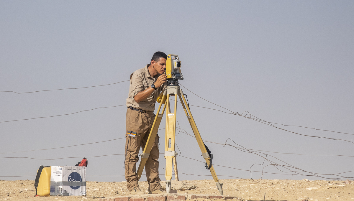
Figure 1: Alessandro measuring with the total station.
Photo: Nicola Dell'Aquila.
These survey methods, which are becoming increasingly popular in archaeological excavations, will occupy a role of growing importance, given its many applications: a three-dimensional model obtained from a photogrammetric survey, in fact, has a wide-ranging potential. Various investigations can be conducted on it: in the case of buildings, their architectural forms can be studied in order to understand the appearance and function they must have had at the time of their construction and later (re)use. On the basis of the photogrammetric survey of the tomb of Meryneith carried out by Alessandro Mandelli a few years ago, for example, I was able to model what the tomb’s original appearance might have been by referring to similar cases and the relevant scientific literature. The possibility to freely navigate within the three-dimensional model allows one to delve into the relationships it had with the surroundings and the surrounding buildings, highlighting any alignments with other features that might missed “live” on the field. And again, by superimposing different surveys made in different days, one can analyse the evolution of the excavation over time; or one can virtually eliminate disturbing elements such as modern additions that hamper an integral reading of the site. One of the most important products of our work, in addition to the three-dimensional models whose peculiarities we have already highlighted, are the orthophotos. These elaborations basically consist of the (perfectly orthogonal) projections of everything we survey on a horizontal plane: this high-resolution image (we work at a resolution in which one pixel corresponds to a tenth of millimetre) is the basis for the two-dimensional redrawing of plans of archaeological sites.
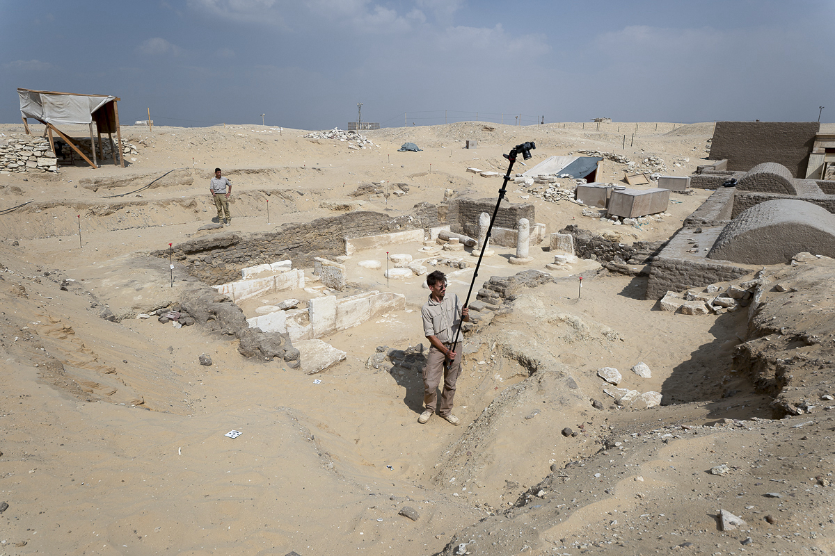
Figure 2: Andrea acquiring images for the photogrammetric elaborations.
Photo: Nicola Dell'Aquila.
But the product of photogrammetric surveys is not just for scholars: its appeal makes it a perfect medium for the dissemination of archaeological knowledge. Indeed, three-dimensional models allow to easily explain how a tomb must have (or rather “could have”) looked like during the New Kingdom, for example, as well as to virtually re-insert artefacts, now preserved in museums around the world, in their original context. Some fragments of reliefs have been found during excavations in the last few days, and in the event that they cannot be physically repositioned in their original location, there is nothing to prevent them from doing so in the digital environment!
In short, photogrammetric surveying has a great potential and many interesting applications, both in the academic and museum fields!
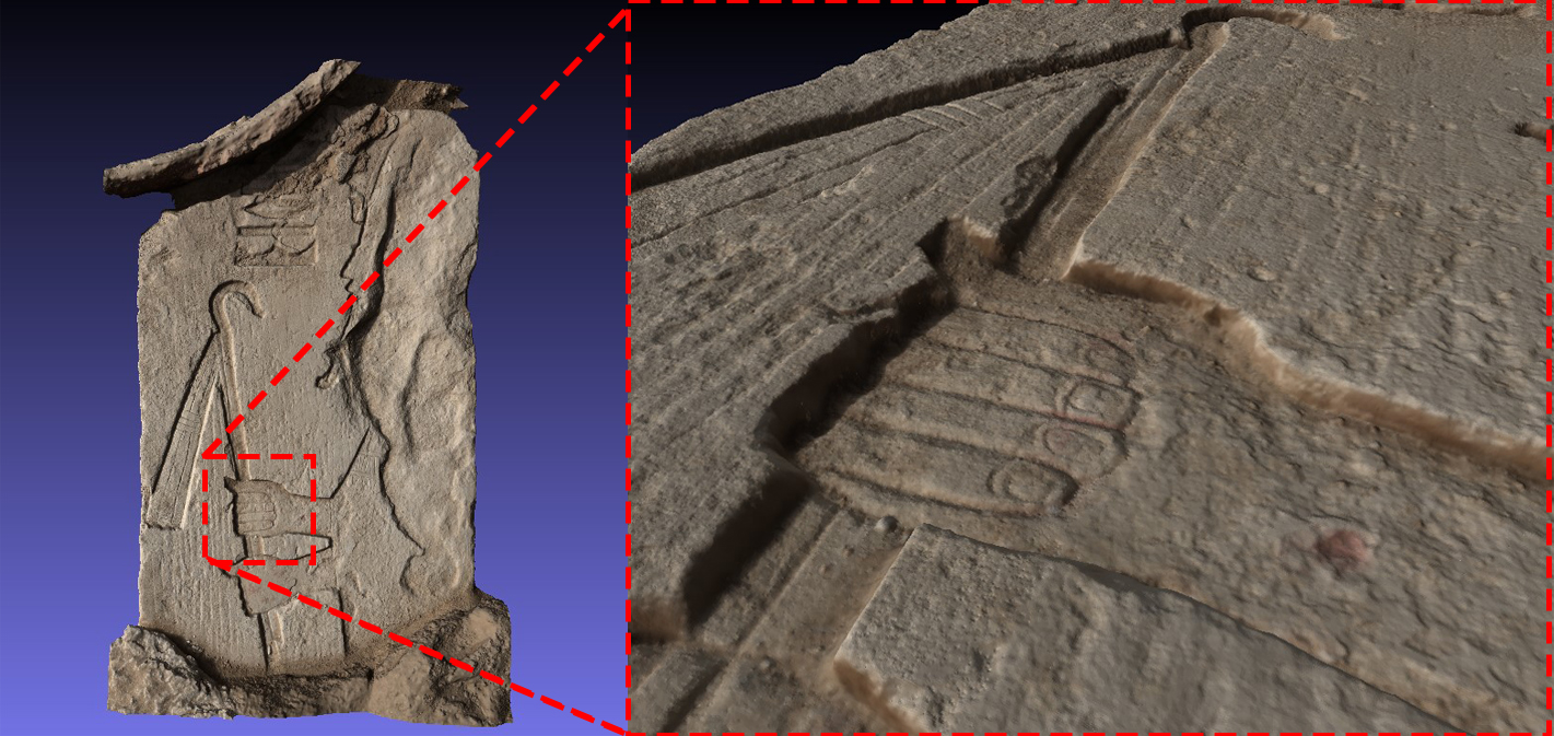
Figure 3: high-resolution 3D model of a relief.
But in practice, what do Alessandro and I do?
Our day begins with the installation of the total station (figure 1): this instrument, the basis of topography, is of paramount importance for our work. In fact, it allows us to measure distances and angles with absolute precision from a previously established topographic point of known coordinates, on which we position the station. The one we use, for example, was acquired in 2019 and is called SAK19P1. Thanks to this, and the use of coded markers that we strategically place around what we must record, every photogrammetric survey we carry out will have precise and unambiguous geographical coordinates. Once the stationing is complete, we can proceed with the actual surveys: we are at the disposal of archaeologists or anyone who needs to create a three-dimensional model of contexts, features or objects. If, during the excavation, a cachette of pottery or human remains or a particular object is found, we proceed with georeferencing its position in the context and then with the actual photogrammetric record: with a digital camera and wide-angle or semi-wide-angle lenses (but sometimes we even have to use fish-eye lenses, if we are working in very narrow spaces!) we take photographs of the object from all angles (figure 2). We then import the topographical data obtained with the total station and the photographs taken and process them into a highly accurate three-dimensional model. We do this several times a day, both for small to medium-sized objects (such as a decorated stele (figure 3)) and for entire contexts (figure 4), as well as for the entire excavation area (figure 5).
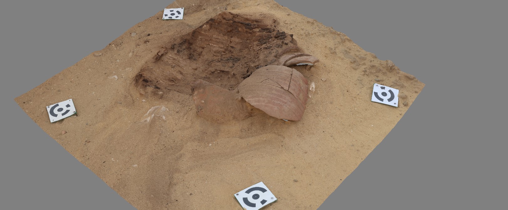
Figure 4: 3D model of a context.
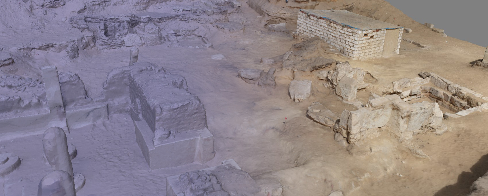
Figure 5: 3D model of the excavation area.
Now I must say goodbye because Alessandro is calling me to order. I’ll get back to holding the camera to tackle new surveys and produce three-dimensional models. Stay here for updates from the other Team members see you soon! Bye!
We look forward to seeing you next Tuesday for a new diary!
Figure 1: Alessandro measuring with the total station.
Photo: Nicola Dell'Aquila.
These survey methods, which are becoming increasingly popular in archaeological excavations, will occupy a role of growing importance, given its many applications: a three-dimensional model obtained from a photogrammetric survey, in fact, has a wide-ranging potential. Various investigations can be conducted on it: in the case of buildings, their architectural forms can be studied in order to understand the appearance and function they must have had at the time of their construction and later (re)use. On the basis of the photogrammetric survey of the tomb of Meryneith carried out by Alessandro Mandelli a few years ago, for example, I was able to model what the tomb’s original appearance might have been by referring to similar cases and the relevant scientific literature. The possibility to freely navigate within the three-dimensional model allows one to delve into the relationships it had with the surroundings and the surrounding buildings, highlighting any alignments with other features that might missed “live” on the field. And again, by superimposing different surveys made in different days, one can analyse the evolution of the excavation over time; or one can virtually eliminate disturbing elements such as modern additions that hamper an integral reading of the site. One of the most important products of our work, in addition to the three-dimensional models whose peculiarities we have already highlighted, are the orthophotos. These elaborations basically consist of the (perfectly orthogonal) projections of everything we survey on a horizontal plane: this high-resolution image (we work at a resolution in which one pixel corresponds to a tenth of millimetre) is the basis for the two-dimensional redrawing of plans of archaeological sites.
Figure 2: Andrea acquiring images for the photogrammetric elaborations.
Photo: Nicola Dell'Aquila.
But the product of photogrammetric surveys is not just for scholars: its appeal makes it a perfect medium for the dissemination of archaeological knowledge. Indeed, three-dimensional models allow to easily explain how a tomb must have (or rather “could have”) looked like during the New Kingdom, for example, as well as to virtually re-insert artefacts, now preserved in museums around the world, in their original context. Some fragments of reliefs have been found during excavations in the last few days, and in the event that they cannot be physically repositioned in their original location, there is nothing to prevent them from doing so in the digital environment!
In short, photogrammetric surveying has a great potential and many interesting applications, both in the academic and museum fields!
Figure 3: high-resolution 3D model of a relief.
But in practice, what do Alessandro and I do?
Our day begins with the installation of the total station (figure 1): this instrument, the basis of topography, is of paramount importance for our work. In fact, it allows us to measure distances and angles with absolute precision from a previously established topographic point of known coordinates, on which we position the station. The one we use, for example, was acquired in 2019 and is called SAK19P1. Thanks to this, and the use of coded markers that we strategically place around what we must record, every photogrammetric survey we carry out will have precise and unambiguous geographical coordinates. Once the stationing is complete, we can proceed with the actual surveys: we are at the disposal of archaeologists or anyone who needs to create a three-dimensional model of contexts, features or objects. If, during the excavation, a cachette of pottery or human remains or a particular object is found, we proceed with georeferencing its position in the context and then with the actual photogrammetric record: with a digital camera and wide-angle or semi-wide-angle lenses (but sometimes we even have to use fish-eye lenses, if we are working in very narrow spaces!) we take photographs of the object from all angles (figure 2). We then import the topographical data obtained with the total station and the photographs taken and process them into a highly accurate three-dimensional model. We do this several times a day, both for small to medium-sized objects (such as a decorated stele (figure 3)) and for entire contexts (figure 4), as well as for the entire excavation area (figure 5).
Figure 4: 3D model of a context.
Figure 5: 3D model of the excavation area.
Now I must say goodbye because Alessandro is calling me to order. I’ll get back to holding the camera to tackle new surveys and produce three-dimensional models. Stay here for updates from the other Team members see you soon! Bye!
We look forward to seeing you next Tuesday for a new diary!
info@museitorino.it
011 44 06 903
From Monday to Saturday from 9:00 a.m. to 6:00 p.m.